
A Glimpse of Orange County, New York
Close to two hundred years before the formation of our nation in 1609, the expedition of Henry Hudson was likely the first recorded time Europeans entered what became Orange County, New York. On his return journey from the regions of Albany towards New York harbor, it was said Hudson dropped anchor near Newburgh Bay and stated: “This is a very pleasant place to build a town on.” Hudson’s sentiments would hold true for the future, but Orange County was still populated by indigenous peoples with the local tribes of the Munsee, a part of the greater Lenni Lenape peoples. It would take another seventy-five years for the first European man, Patrick MacGregorie, to settle on the New Windsor/Newburgh border in 1685. Shortly after his settlement, many land patents became available to new settlers through the early eighteenth century. Some of the better-known land patents include the 1702 Cheesecock Patent that included the town of Monroe, the 1703 Wawayanda Patent, and the 1704 Minisink Patent. Other patents often overlapped into Orange County, such as the one granted to French Huguenots that included Peter Gumaer and Jacob Cuddeback who of Deerpark around 1690 and received rights over their 1,200 acres by 1697.
Orange County was created in November, 1683 as one of New York’s twelve original counties, taking its name from King William III, Prince of Orange. Its borders were vastly different compared to today. Everything north of the towns of Cornwall, Goshen, and Wawayanda was a part of Ulster County. Likewise, all of present-day Rockland County was encompassed by Orange. The county was sparsely populated as the 1698 census indicated a population of 29 men, 31 women, 140 children, and 19 enslaved persons. The counties of Orange and Dutchess were the only two in New York that were at first put under the government of surrounding counties (Orange was governed by Manhattan and Dutchess by Ulster). This changed over time and by the year 1703, the county had its own governing board. The geography of Orange County soon proved to be challenging, with the Ramapo Mountains slicing one portion of the county from the other. Traversing this area became so treacherous that two county seats were established, one in Orangetown to the south and another in Goshen to the north. This geographical dilemma later led to the creation of Orange County’s present-day borders. In the year 1798, Rockland County was created in the region south of the Hudson Highlands, while the lands north remained in Orange County. The towns of Deerpark, Montgomery, New Windsor, Wallkill, and Newburgh were subsequently added, accounting for a final area of approximately 839 square miles.
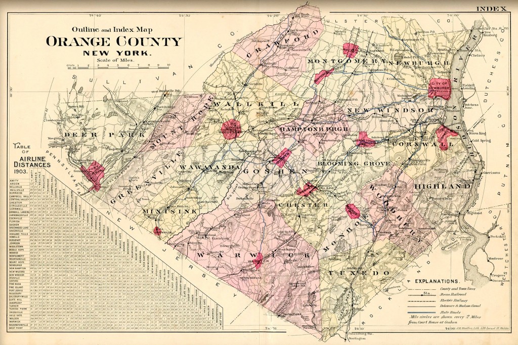
Orange County’s central regions, encompassing the towns of Wawayanda, Wallkill, Goshen, Chester, Blooming Grove, Hamptonburgh, and Warwick, are well-known for their agricultural activity. Grasses in these low-lying regions tended to produce the richest quality of milk compared to mountain pastures. Additionally, nearby mountain ranges form what some may call protective borders. The southeastern edge is bordered by the Schunnemunk, Warwick, Bellvale, and Ramapo ranges while the northwestern border is defined by the Shawangunks. The central low-lying region, known in the southern reaches of the county as the Drowned Lands, extends northward to the towns of Blooming Grove and New Windsor. The region gets its name from the three-mile-thick glaciers that, even after thousands of years of melting, left large lakes and expansive swamps. Here, the fertile plain ends just north of Blooming Grove and becomes more mountainous. This can also be said of the northern region where the Shawangunks give the towns of Montgomery and Crawford a more elevated terrain. In the county’s southeastern and western regions, two prominent mountain ranges of Orange County with elevations reaching over 1,000 feet in some areas. In the southeastern region, the Ramapo Mountains extend north from the New Jersey Highlands to the Hudson River just south of Newburgh. It is in this range where the Highlands slice the land in a series of diagonal striations, creating numerous valleys known as cloves such as Smith’s Clove in the town of Woodbury. Here, within the valleys, the towns of Cornwall, Woodbury, Monroe, Arden, and Tuxedo are found. Likewise, to the west, New Jersey’s Kittatinny Mountain becomes the Shawangunk Range in Orange County where the city of Port Jervis is practically separated from the rest of the area. This obstacle, however, did not hinder the city from being an industrial and transportation hub.


Building a Network of Orange County’s Local History
Since my first involvement with many of the regions historical societies, it has been a consistent goal of mine to promote collaboration among the theme of local history. In my capacity of working with these organizations, and processing artifacts for other collections I steward such as the Orange County Milk Bottle Museum of Edward J. Crist Archive of Orange County Railroading History, I have developed a library of Orange County history. For those looking to learn more about the rich past of our region, I welcome sharing the information held in my library with wide audiences.
Beyond this, in my capacity as town historian of Woodbury and a member of the Association of Public Historians of New York State, I maintain relationships with nearly all of Orange County’s city, town, and village historians in addition to several historians in neighboring counties. If you have a question that I am unable to answer, it is my pleasure to direct you to a fellow colleague with more knowledge.
For research inquiries or other questions, please contact me here:


